Software
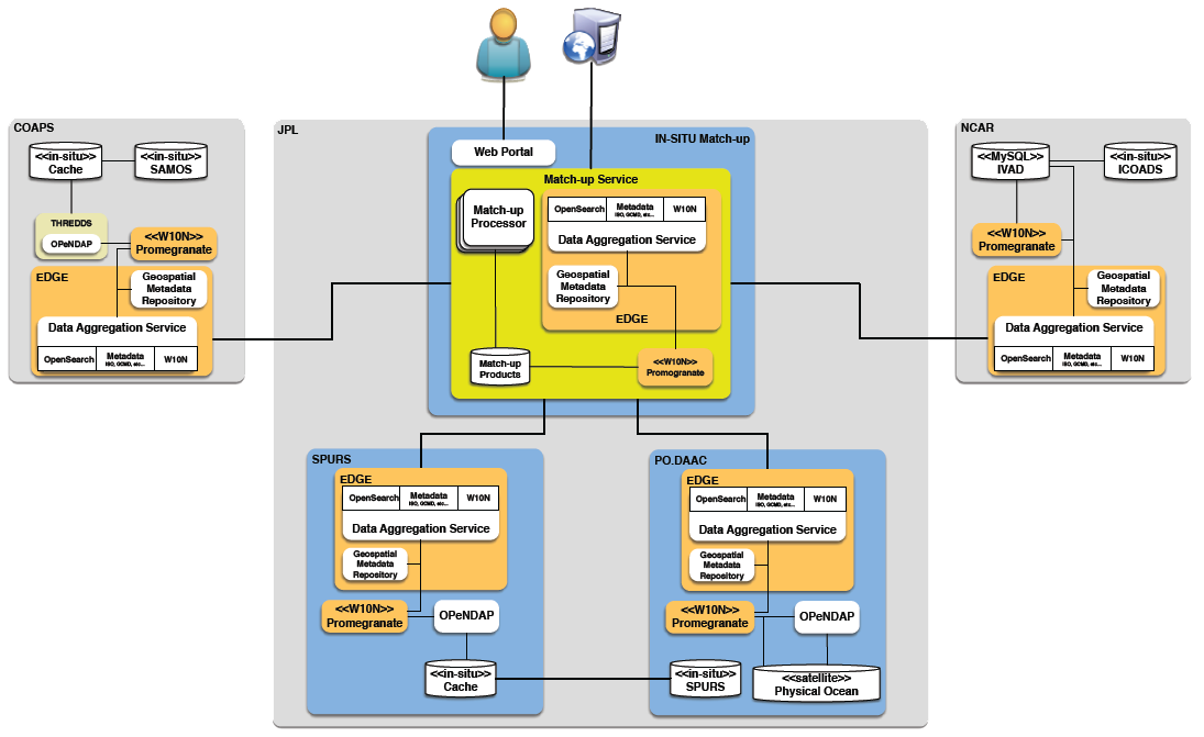
Throughout the DOMS project, FSU has contributed to the software code base for this distributed match-up service. During the second phase of the project to infuse DOMS into the OceanWorks Science Data Analytics Platform, the prototype was enhanced to support filtering in-situ data based on quality control flags and to export matched data into network common data form (netCDF) files. The following software were either implemented (EDGE) or developed (DOMS netCDF reader) by the FSU team. The latest version of EDGE was also implemented by NCAR for the ICOADS DOMS node and within the SPURS/satellite nodes at JPL.
- EDGE Source Code
- DOMS NetCDF reader for matched data records
Technical Documents
The use cases, technical specifications, and conceptual designs, along with original translation specifications, were drafted during the development of the 2017 DOMS prototype. During a follow-on project to infuse DOMS into the OceanWorks Science Data Analytics Platform, the prototype was enhanced to support filtering in-situ data based on quality control flags. Changes in the translation specifications to include quality flags are included in the documentation provided below.
- DOMS Concept Plan
- DOMS Use Cases
- DOMS User Interface Design
- DOMS Translation Specifications
Why DOMS?
DOMS is needed by the marine and satellite research communities to support a range of activities. Use cases include, but are not limited to (1) iterative calibration/validation of satellite retrieval algorithms, (2) decision support for designing and implementing field campaigns, (3) scientific investigations (e.g., developing blended satellite-in situ products, process studies), and (4) quality control of surface marine observations. For example, satellite cal/val requires a user to identify co-located satellite observations to observations of the same type from ships, buoys, or floats. For each in situ measurement, the user must determine whether or not a satellite observation can be matched to the in situ data with sufficiently small space and time tolerances. Traditionally, researchers match observations by downloading large volumes of satellite and in situ data to local computers and using independently developed one-off software. Frequent repetition of this process consumes substantial human and machine resources. The proposed service will provide a community accessible tool that dynamically provides data matchups and allows the scientist to only work with the subset of data where the matches exist.

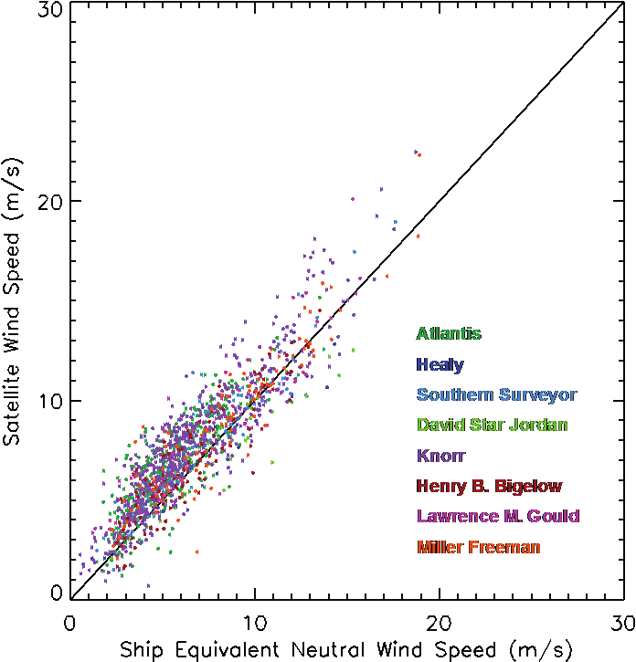
Example comparing collocated ship and satellite scatterometer wind speed data.
This analysis was done during a validation exercise for QuikScat.
About
Goals
What is DOMS?
The Distributed Oceanographic Match-up Service (DOMS) is a web-accessible service tool that will reconcile satellite and in situ datasets in support of NASA’s Earth Science mission. Read More...
Why DOMS?

DOMS is needed by the marine and satellite research communities to support a range of activities. Read More...
Partners
Goals
To develop a distributed web-accessible service to match satellite and in situ marine observations to support platform comparisons, cross-calibration, validation, and quality control.


